San Francisco landmarks
Photo: King of Hearts · CC BY-SA 3.0

Landmarks

San Francisco's Most Iconic Landmarks

A deep guide to San Francisco's iconic landmarks: the Golden Gate Bridge, Alcatraz, and Coit Tower, with history and insider visiting tips.

San Francisco wears its history in redwood, painted wood, and International Orange steel.

This is the city that rebuilt itself from ash after the 1906 earthquake and fire, that gave the world the first cable car system when Andrew Hallidie's cars climbed Clay Street in 1873, and that turned a wind-scoured peninsula between ocean and bay into one of the most photographed skylines on earth.

To walk its hills is to move through a compressed catalogue of American ambition, where a 1915 exposition palace stands within sight of a mid-century pyramid, and where the fog rolls through a bridge that engineers once called impossible.

What makes San Francisco's landmarks so compelling is that they are shaped by geography as much as by design. They cling to steep hills, ring the waterfront, and frame the Golden Gate in a way that lets you read the city block by block, view by view.

The bridges span the water with a confidence that still feels audacious, the cable cars grind up grades that defeated horses, and the museums in Golden Gate Park hold collections that draw visitors from around the world.

The bay and the Pacific, cold and restless, tie it all together and give the city its silver light.

This guide gathers eleven landmarks that define San Francisco: the record-setting bridge, the notorious island prison, the beloved works of public architecture, the world-class museums, and the everyday cable cars that changed how a hilly city could grow.

For each you will find what it is, why it matters, what to look for, and how to visit sensibly. Read it front to back for an architectural narrative of the city, or skip to the places that call to you and build your own route along the hills and the shore.

Bridge · Presidio / Golden Gate · 1937

Golden Gate Bridge

The International Orange span that strides across the strait through fog and sun, the single image the whole world reads as San Francisco.

The Golden Gate Bridge leaps across the mile-wide strait where San Francisco Bay meets the Pacific, connecting the tip of the city to the Marin headlands.

Chief engineer Joseph Strauss led the project, but the elegant final form owes as much to engineer Charles Ellis, who worked out the mathematics of the suspension design, and to consulting architect Irving Morrow, who gave the towers their stepped Art Deco profile and chose the now-famous color.

That color, International Orange, was selected over the gray or striped schemes the Navy preferred because it complements the landscape and stands out in fog, and crews repaint the bridge continuously to hold back the corrosion of the salt air.

When it opened it was both the longest and the tallest suspension bridge in the world, its two towers rising some seven hundred and forty-six feet and its main span stretching four thousand two hundred feet between them.

The bridge is a working roadway, but it is also a walk, a photograph, and a pilgrimage. Sidewalks on the eastern side carry pedestrians and cyclists out over the water, where the cables sweep down and back up in a long catenary curve and the deck hums under passing traffic.

The great drama here is the weather: the fog that pours through the gate on summer afternoons can swallow the towers whole, leaving only their red tips floating above a white sea.

Visiting

The bridge is free to walk or cycle across, and the eastern sidewalk is open to pedestrians during daylight hours while cyclists have extended access. The Welcome Center and gift shop sit at the southern end near the toll plaza, with parking that fills quickly on clear days. For the classic postcard view, drive or walk to the Marin side and up to the Battery Spencer overlook, or stay in the city and head to Fort Point directly beneath the southern tower. Dress warmly and expect wind even in summer, and check a fog forecast, since a clear morning often clouds over by afternoon.

Insider tip: Cross to the Marin side early in the morning for the best odds of a fog-free view, then time your return for late afternoon when the fog rolls in: seeing the bridge both clear and shrouded in one visit is the fullest way to understand it.

📍 View on Google Maps →

Historic · San Francisco Bay · 1934

Alcatraz Island

A fortress prison marooned on a cold rock in the bay, where the cell blocks still echo with the names of America's most notorious inmates.

Alcatraz Island rises from the frigid, current-swept waters of San Francisco Bay, a bare rock that has served as a lighthouse station, a Civil War fort, and, most famously, the federal penitentiary that gave it worldwide notoriety.

From 1934 to 1963 it held the prisoners the system considered most dangerous or hardest to hold, including Al Capone and the bank robber George Machine Gun Kelly, in a maximum-security facility designed to be all but impossible to escape.

The island's isolation was its wall: the cold water, the strong currents, and the mile and a half to shore were meant to defeat any swimmer.

Only a handful of inmates ever attempted escape, and the fate of the famous 1962 breakout by the Anglin brothers and Frank Morris, who left dummy heads in their beds and vanished into the bay, remains officially unsolved to this day.

After the prison closed, the island took on another chapter of American history when Native American activists occupied it from 1969 to 1971 to protest federal policy, leaving graffiti that is now preserved as part of the story.

Today the island is part of the Golden Gate National Recreation Area, and its cell house, weathered buildings, and unexpectedly lush gardens draw visitors into a haunting, windblown landmark with some of the finest skyline views in the region.

Visiting

Alcatraz is reached only by the official ferry, which departs from Pier 33 on the Embarcadero, and tickets sell out days or even weeks ahead in peak season, so book early. The visit centers on the excellent self-guided cell house audio tour, narrated in part by former guards and inmates, which typically runs about forty-five minutes but can stretch far longer. Allow two to three hours for the whole outing including the crossing, and bring layers, since the island is windy and cold even when the city is warm. The night tour offers a smaller crowd and an especially eerie atmosphere.

Insider tip: Book the night tour if you can: the group is smaller, the light on the bay is spectacular, and rangers lead extra programs that the daytime ticket does not include, all with the city glittering across the water.

📍 View on Google Maps →

Historic · Telegraph Hill · 1933

Coit Tower

A slender Art Deco column atop Telegraph Hill, wrapped inside with Depression-era murals of California life.

Coit Tower stands at the crest of Telegraph Hill, a fluted concrete column two hundred and ten feet tall that has become one of the city's most beloved silhouettes.

It was built with a bequest from Lillie Hitchcock Coit, an eccentric heiress who as a girl became an honorary member of a volunteer fire company, and legend long held that the tower was shaped to resemble a fire hose nozzle, though its architect Arthur Brown Jr.

always denied any such intent.

The tower's true treasure waits inside at ground level: a continuous cycle of frescoes painted in 1934 by more than two dozen artists under the New Deal Public Works of Art Project.

Executed in the social-realist style influenced by Diego Rivera, the murals depict California workers in fields, factories, libraries, and city streets, and a few details were controversial enough at the time to briefly delay the tower's opening.

An elevator carries visitors to the observation platform at the top, where one of the great three-hundred-and-sixty-degree panoramas of San Francisco opens up: the bay and its bridges, the downtown towers, the neighborhoods spilling over the hills, and the boats crossing toward Alcatraz and Angel Island.

The approach up the hill is a pleasure in itself, whether by the winding road or the leafy Filbert and Greenwich Steps, where wild parrots often call from the trees.

Visiting

Coit Tower is open daily, with the ground-floor murals free to view and a modest fee to ride the elevator to the observation deck. Parking at the top is very limited and the small lot backs up quickly, so many visitors climb the Filbert or Greenwich Steps from the Embarcadero side or take the bus partway up. Go on a clear day for the views, and arrive near opening to avoid both the crowds and the wait for the single small elevator. Allow an hour, more if you linger over the murals or the stairways.

Insider tip: Walk up via the Greenwich or Filbert Steps rather than driving: the garden-lined staircases are one of the city's hidden delights, and you may spot the famous wild parrots of Telegraph Hill along the way.

📍 View on Google Maps →

Historic · Marina District · 1915

Palace of Fine Arts

A romantic Roman rotunda reflected in a swan-filled lagoon, the last survivor of a vanished world's fair.

The Palace of Fine Arts presides over a tranquil lagoon in the Marina District, a monumental open rotunda ringed by a curving colonnade that looks like a fragment of ancient Rome transported to the California shore.

It was designed by Bernard Maybeck for the Panama-Pacific International Exposition of 1915, the world's fair that celebrated the completion of the Panama Canal and announced San Francisco's recovery from the great earthquake and fire of 1906.

Maybeck conceived it as a deliberately melancholy ruin, an evocation of vanished grandeur meant to put visitors in a contemplative mood before they entered the art galleries beyond.

The octagonal rotunda and its weeping maidens atop the colonnade were built quickly and cheaply for the fair in plaster and burlap, never meant to last, yet the structure was so loved that it survived long after every other exposition palace was demolished.

By the 1960s the original had crumbled beyond repair, and the whole ensemble was cast anew in permanent concrete so that its beauty could endure.

Today the grounds are a public park where couples pose for wedding photographs, families feed the ducks and swans, and the great dome reflects in the still water.

It is one of the most photographed and most serene spots in the city, equally rewarding at golden dawn or floodlit night.

Visiting

The Palace of Fine Arts grounds and lagoon are a public park, free and open at all hours, with no ticket required to wander beneath the rotunda or around the water. Street parking is available nearby, and the site sits within easy reach of the Marina Green, Crissy Field, and the walk toward the Golden Gate Bridge. Early morning offers glassy reflections and few people, while evening brings dramatic lighting of the dome. Allow half an hour to stroll, longer if you picnic by the lagoon or continue along the waterfront.

Insider tip: Come at first light for a mirror-smooth reflection of the rotunda in the lagoon before the crowds and the breeze arrive, then walk a few minutes north to Crissy Field for a completely different view of the bay and the bridge.

📍 View on Google Maps →

Historic · Embarcadero · 1898

Ferry Building

A grand waterfront hall under a Seville-inspired clock tower, reborn as the city's temple of food.

The Ferry Building anchors the foot of Market Street on the Embarcadero waterfront, its long arcaded facade crowned by a two-hundred-and-forty-five-foot clock tower modeled on the Giralda bell tower of Seville Cathedral. Designed by architect A.

Page Brown and opened in 1898, it was for decades the second-busiest transit terminal in the world, funneling tens of thousands of commuters who crossed the bay by ferry before the great bridges were built.

When the Bay Bridge and Golden Gate Bridge opened in the 1930s, ferry traffic collapsed and the building slid into decline, later hidden behind an elevated freeway that walled it off from the city.

The Loma Prieta earthquake of 1989 damaged that freeway so badly that it was torn down, reopening the waterfront and setting the stage for the building's celebrated revival.

Restored and reopened in 2003, the Ferry Building now houses a soaring interior nave lined with artisan food shops, cheesemongers, bakeries, oyster bars, and cafes celebrating the bounty of Northern California.

Several days a week the plazas outside fill with one of the country's finest farmers markets, where the region's farmers and foragers sell directly to chefs and home cooks.

Ferries still depart from the slips behind the building, so it remains a living gateway between the city and the bay.

Visiting

The Ferry Building marketplace is open daily, free to enter, with individual shops and restaurants keeping their own hours and the farmers market running on select mornings, most famously Saturday. It sits at the eastern end of Market Street, easily reached by the historic F-line streetcar, BART, Muni, or a stroll along the Embarcadero. Come hungry and early on a market day for the fullest selection, and consider timing a visit around a ferry ride to Sausalito or Oakland. Allow an hour to browse, longer if you sit down to eat with a bay view.

Insider tip: Visit on a Saturday morning when the outdoor farmers market wraps around the building: it is the best time to taste your way through Northern California produce and to catch chefs shopping alongside you.

📍 View on Google Maps →

Landmark · Russian Hill · 1922

Lombard Street

The crookedest block in the city, a ribbon of hairpin turns tumbling down the hill through banks of hydrangeas.

The famous stretch of Lombard Street coils down the eastern face of Russian Hill in a single steep block between Hyde and Leavenworth, its eight tight switchbacks earning it the reputation as the crookedest street in the world.

The serpentine layout was engineered in 1922 to tame a slope so severe, roughly a twenty-seven percent grade, that a straight roadway would have been treacherous for cars and pedestrians alike.

The curves are set in red brick paving and threaded between beautifully tended flower beds, where hydrangeas bloom in great blue and pink drifts through the warmer months and give the descent its picture-book charm.

Elegant homes line both sides, their residents living with the daily reality of a nonstop parade of sightseers and slow-rolling cars easing through the turns.

Driving down the block, one careful hairpin at a time, is a quintessential San Francisco experience, but many visitors prefer to walk the stairways that flank either side, which offer the best views back up the flowered curves and out toward Coit Tower and the bay beyond.

It is a reminder that in this city the topography shapes everything, forcing streets, houses, and daily life to bend to the will of the hills.

Visiting

Lombard Street is a public road, free to drive or walk at any time, though the crooked block runs one way downhill from the top at Hyde Street. Expect long lines of cars waiting to make the descent on weekends and summer afternoons, and note that parking in the neighborhood is scarce and tightly regulated. Many people ride the Powell-Hyde cable car to the top, take in the view, and walk down the staircases rather than drive. Go early in the day for thinner crowds and better light on the flowers.

Insider tip: Skip the driving queue and instead climb the pedestrian steps alongside the curves: from partway down you get the classic head-on photograph of the switchbacks with the bay framed behind them, impossible to capture from a car.

📍 View on Google Maps →

Historic · Nob Hill / Powell Street · 1873

Cable Cars

The last hand-operated cable railway on earth, clanging up and down the hills exactly as it has for a century and a half.

San Francisco's cable cars are the world's last manually operated cable railway system still in daily service, a moving national landmark that climbs the city's steepest hills by gripping a continuously running cable buried beneath the street.

The system was born in 1873 when Andrew Hallidie, moved by the sight of horses struggling and falling on the wet cobbles, devised a way to haul cars up the slopes using the same wire-rope technology used in mining.

Each car has no engine of its own; instead the gripman operates a great lever that clamps onto or releases the moving cable running at a steady nine and a half miles per hour, while a second crew member works the brakes.

All the cables run out from a central powerhouse on Nob Hill, where visitors can watch the enormous winding wheels turn through the windows of the free Cable Car Museum.

Three lines survive today: the Powell-Hyde and Powell-Mason lines climbing from the downtown turntable near Union Square out toward Fisherman's Wharf, and the California Street line running east to west through the Financial District and Chinatown.

Riding one is not merely transport but a plunge into the nineteenth century, the car swaying and clanging its bell as it crests a hill and the whole bay suddenly opens up below.

Visiting

The cable cars run daily as part of the Muni transit system, and a single ride requires a flat fare payable to the conductor, on a mobile app, or with a day pass that also covers the buses and streetcars. Lines at the Powell Street turntable near Union Square can be very long, so board instead at a stop farther along the route, or ride the quieter California Street line. Hang on tight, and for the full thrill ride standing on the running board at the edge. The free Cable Car Museum on Nob Hill is well worth a visit to see the machinery in motion.

Insider tip: Avoid the long turntable queue by walking a few blocks up the line and catching a car at a regular stop: you will usually get on faster, and the California Street line in particular is far less crowded than the Powell Street routes.

📍 View on Google Maps →

Historic · Alamo Square · 1894

Painted Ladies (Alamo Square)

A row of pastel Victorian houses posed against the downtown skyline, the most photographed street corner in the city.

The Painted Ladies are a row of Victorian houses along Steiner Street facing Alamo Square, universally known as Postcard Row for the way they line up in front of the modern downtown skyline.

The seven houses were built in the 1890s in the Queen Anne style and later repainted in the multicolored schemes that highlight their elaborate wooden ornament, the trim, brackets, and gingerbread details picked out in contrasting hues.

San Francisco was once covered in tens of thousands of such wooden Victorians, but fires, earthquakes, redevelopment, and changing tastes destroyed most of them.

The term Painted Ladies was coined in the 1970s to describe old Victorians repainted in three or more colors to emphasize their architectural details, and this particular row became the most celebrated example anywhere.

The houses gained worldwide fame as a television backdrop and now appear on countless postcards, calendars, and films, drawing a steady stream of visitors up the grassy slope of Alamo Square Park to capture the classic juxtaposition of nineteenth-century domestic architecture against the towers of the twenty-first-century city.

The park itself, with its lawns and shade trees, is a pleasant place to picnic while admiring the survivors of a lost architectural era.

Visiting

The Painted Ladies are private residences, so the experience is entirely from the outside, and the best vantage point is the eastern slope of Alamo Square Park directly across Steiner Street. The park is free and open daily, with the classic view of the houses lined up before the skyline drawing photographers throughout the day. Late afternoon light warms the pastel facades, while clear mornings give the sharpest skyline behind them. Please respect that people live here, and admire from the park rather than the doorsteps.

Insider tip: Climb to the top of the grassy hill in Alamo Square Park and frame the houses low against the distant downtown towers: the higher you stand, the more dramatically the Victorian rooflines play off the modern skyscrapers behind them.

📍 View on Google Maps →

Museum · Golden Gate Park · 2008

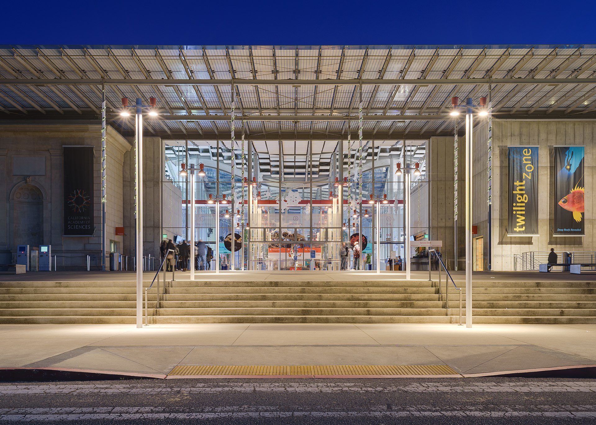
California Academy of Sciences

An aquarium, planetarium, and rainforest gathered under a living roof of native wildflowers in the heart of the park.

The California Academy of Sciences sits in the middle of Golden Gate Park, an extraordinary institution that combines an aquarium, a planetarium, a natural history museum, and a four-story indoor rainforest under a single roof.

The academy itself is one of the oldest scientific institutions in the country, but its current home, designed by the Italian architect Renzo Piano and opened in 2008, reinvented it as a showcase of sustainable design.

The building's most striking feature is its undulating living roof, planted with native Californian wildflowers and grasses that rise and fall in green hills echoing the city's topography, cooling the building and sheltering local wildlife.

Skylights and glass walls flood the interior with daylight, and the whole structure earned the highest environmental rating, a deliberate statement that a museum of the natural world should tread lightly upon it.

Inside, visitors descend into the Steinhart Aquarium to walk beneath a coral reef, climb through the humid glass dome of the Osher Rainforest among free-flying butterflies and birds, and recline beneath the Morrison Planetarium's all-digital dome for immersive journeys through the cosmos.

An albino alligator, a colony of penguins, and a specimen-filled naturalist center round out a place that manages to be both a serious research institution and one of the most delightful family attractions in the city.

Visiting

The California Academy of Sciences is open daily, and admission is ticketed, with prices at the higher end for museums, so booking timed tickets online in advance is wise and can save money. It stands in Golden Gate Park directly across the Music Concourse from the de Young Museum, reachable by bus, bike, or car, though park parking fills fast on weekends. Weekday mornings are calmer than weekends, when families arrive in force. Allow at least half a day to take in the aquarium, rainforest, and a planetarium show, which requires a separate timed reservation on arrival.

Insider tip: Reserve your planetarium show time as soon as you enter, since the popular slots fill quickly, then explore the aquarium and rainforest around it: on select evenings the adults-only NightLife event turns the whole museum into a lively party with cocktails.

📍 View on Google Maps →

Skyscraper · Financial District · 1972

Transamerica Pyramid

A tapering white spire that defied its critics to become the unmistakable exclamation point of the skyline.

The Transamerica Pyramid rises from the edge of the Financial District as a slender four-sided spire that narrows to a point, an eight-hundred-and-fifty-three-foot tower that was for decades the tallest building in San Francisco.

Designed by the architect William Pereira and completed in 1972, its radical shape was fiercely controversial at the time, denounced by critics who felt a pyramid had no place among the conventional boxes of a business district.

Pereira argued that the tapering form was practical as well as expressive: by shrinking as it rose, the tower cast smaller shadows and let more light and air reach the streets below than a bulky rectangular slab would.

Two hollow wings flare out from the upper floors, one housing an elevator shaft and the other a stairwell, and the whole structure is sheathed in crushed white quartz that makes it glow against the sky.

Designed to withstand the region's earthquakes with a deep foundation and a flexible frame, the pyramid rode out the 1989 Loma Prieta quake without damage.

Though it was surpassed in height by the Salesforce Tower in 2018, it remains the most instantly recognizable form on the skyline, and the small redwood grove planted at its base offers a shady, unexpected pocket of calm amid the downtown bustle.

Visiting

The Transamerica Pyramid is a private office building, so the experience is primarily from the outside, appreciating its form from the surrounding streets and from more distant vantage points across the city where its spire pins down the skyline. The half-acre Transamerica Redwood Park at its base, tucked along Washington Street, is open to the public on weekdays and makes a peaceful spot to sit among the trees. The building is an easy stop while exploring the Financial District, Chinatown, or the nearby Jackson Square historic blocks. Any time of day works for admiring the exterior.

Insider tip: For the best full-skyline shot with the pyramid rising above the other towers, head to Coit Tower on Telegraph Hill or across the water to Treasure Island: from a distance the spire reads far more dramatically than it does from directly below.

📍 View on Google Maps →

Waterfront · Fisherman's Wharf · 1978

Fisherman's Wharf and Pier 39

A boisterous waterfront of sourdough, crab pots, and a raucous colony of sea lions basking on the docks.

Fisherman's Wharf spreads along the northern waterfront, a historic fishing harbor that grew from the Italian and other immigrant fishermen who worked these waters and still supplies the city with Dungeness crab in season.

The wharf remains a working port in part, its lagoon crowded with fishing boats, while its walkways brim with seafood stands serving crab cocktails and clam chowder ladled into hollowed-out rounds of the city's famous tangy sourdough bread.

At its lively eastern end stands Pier 39, a festive boardwalk of shops, restaurants, street performers, and a vintage carousel that opened in 1978.

Its most beloved and entirely unplanned attraction arrived after the Loma Prieta earthquake of 1989, when hundreds of California sea lions hauled themselves onto the pier's boat docks and simply stayed, barking, jostling, and sunbathing in a heaving mass that now draws crowds year-round.

Beyond the crab stands and souvenir shops, the district holds genuine history and sweeping views: the vessels of the San Francisco Maritime National Historical Park moored at Hyde Street Pier, the World War II submarine USS Pampanito, and clear sightlines out to Alcatraz and the Golden Gate Bridge.

It is unabashedly touristy, but the salt air, the sea lions, and the smell of sourdough and crab make it an essential and enjoyable slice of the city.

Visiting

Fisherman's Wharf and Pier 39 are open public areas, free to wander, with individual shops, restaurants, and attractions ticketed separately and the sea lions viewable at no charge on the pier's western docks. The district is reachable by the Powell-Hyde and Powell-Mason cable car lines, the historic F-line streetcar, or a waterfront walk, and it makes a natural launch point for Alcatraz and bay cruises from the nearby piers. Come in the morning for fewer crowds, and check that crab is in season, roughly late autumn into spring, for the freshest local catch. Allow a couple of hours or more.

Insider tip: Head straight to the K-Dock on the west side of Pier 39 to watch the sea lions, then buy your crab and chowder from the outdoor stands rather than the sit-down restaurants: the food is fresher, cheaper, and best eaten looking out over the water.

📍 View on Google Maps →

Frequently Asked Questions

What are the best landmarks to see if I only have limited time in San Francisco?

Prioritize the northern waterfront and hills: ride a cable car from Powell Street, walk or bike across the Golden Gate Bridge, and take in the view from Coit Tower on Telegraph Hill. If time allows, add the Ferry Building and Fisherman's Wharf, with a ferry glimpse of Alcatraz from the bay.

Which iconic San Francisco landmarks are free to visit?

The Golden Gate Bridge is free to walk or cycle, and the surrounding Presidio and Crissy Field cost nothing. Alamo Square and its Painted Ladies, Lands End, and the base of Coit Tower are all free, as is the observation floor of the de Young Museum's Hamon Tower. Alcatraz ferries and cable car rides charge fares.

How many days do I need to see San Francisco's iconic landmarks?

Two full days cover the essentials: one for the Golden Gate Bridge, the Presidio, and the Palace of Fine Arts, and another for the cable cars, the Ferry Building, Coit Tower, and the waterfront. Three days is ideal, adding an Alcatraz tour, Golden Gate Park's museums, and Alamo Square.

What is the best way to see San Francisco's architecture and skyline?

A bay cruise or the ferry to Sausalito gives the best introduction, framing the skyline, the Transamerica Pyramid, and the Golden Gate Bridge from the water. Add a cable car ride over Nob Hill, a walk down crooked Lombard Street, and the view from Twin Peaks for the full sweep of the city.

Should I go up Twin Peaks or Coit Tower for the view?

Twin Peaks sits higher and gives a sweeping panorama of the whole city, the bay, and both bridges, best reached by car or rideshare. Coit Tower on Telegraph Hill is closer to downtown, has a small paid elevator to the top, and rewards you with 1930s WPA murals along the way. Choose Twin Peaks for the panorama, Coit Tower for history and convenience.

When is the best time of year to visit San Francisco's landmarks?

September and October are prime, with the warmest, clearest weather and the city's famous summer fog largely gone. Spring brings mild days and fewer crowds. Summer is busiest but can be surprisingly cold and foggy near the coast, so pack layers. Winter is quieter, greener, and good for indoor museums between showers.